
Umetatechi, the 850-Year-Old Japanese Practice of Expanding into the Sea
Japan’s centuries-long practice of land reclamation, umetatechi has profoundly reshaped its cities—from medieval ports to modern megaprojects—bringing both growth and seismic challenges.
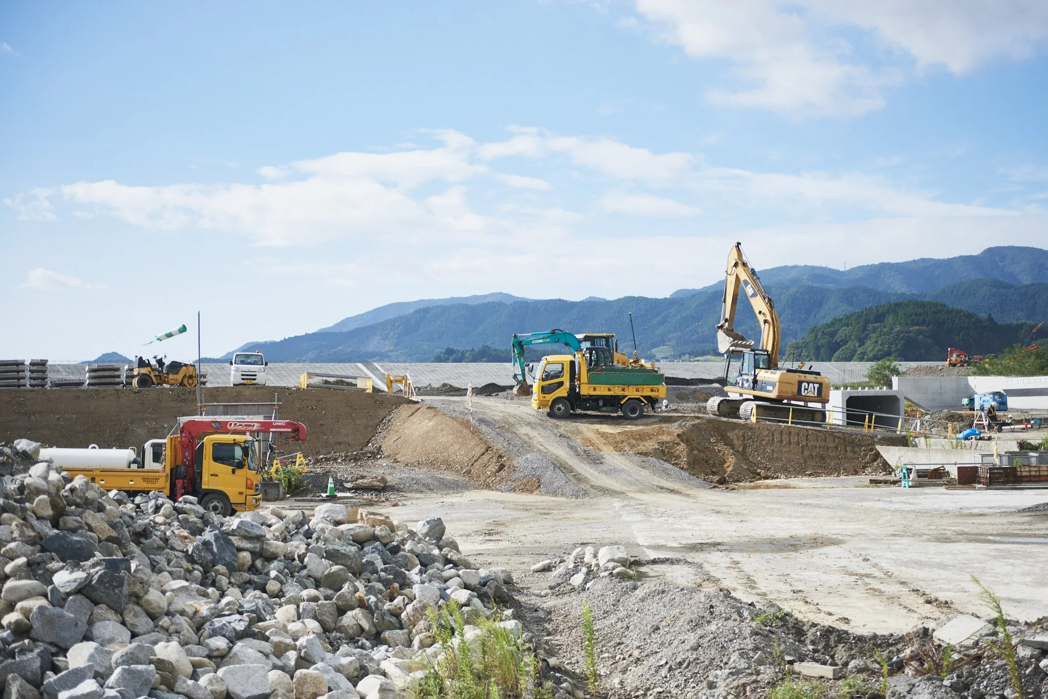
Just over 29 million people visited Expo 2025 Osaka, arriving from all over the world to take in the various technological and cultural wonders. But the most impressive part of the world fair may have been the ground beneath their feet, as the entire event took place on the still-expanding artificial island of Yumeshima, which will be nearly four square kilometers upon completion.
Land reclamation is common in the industrialized world. What sets Japan’s construction of reclaimed land, or umetatechi, apart is how long it has been going on for and how much it has reshaped Japan's cities.
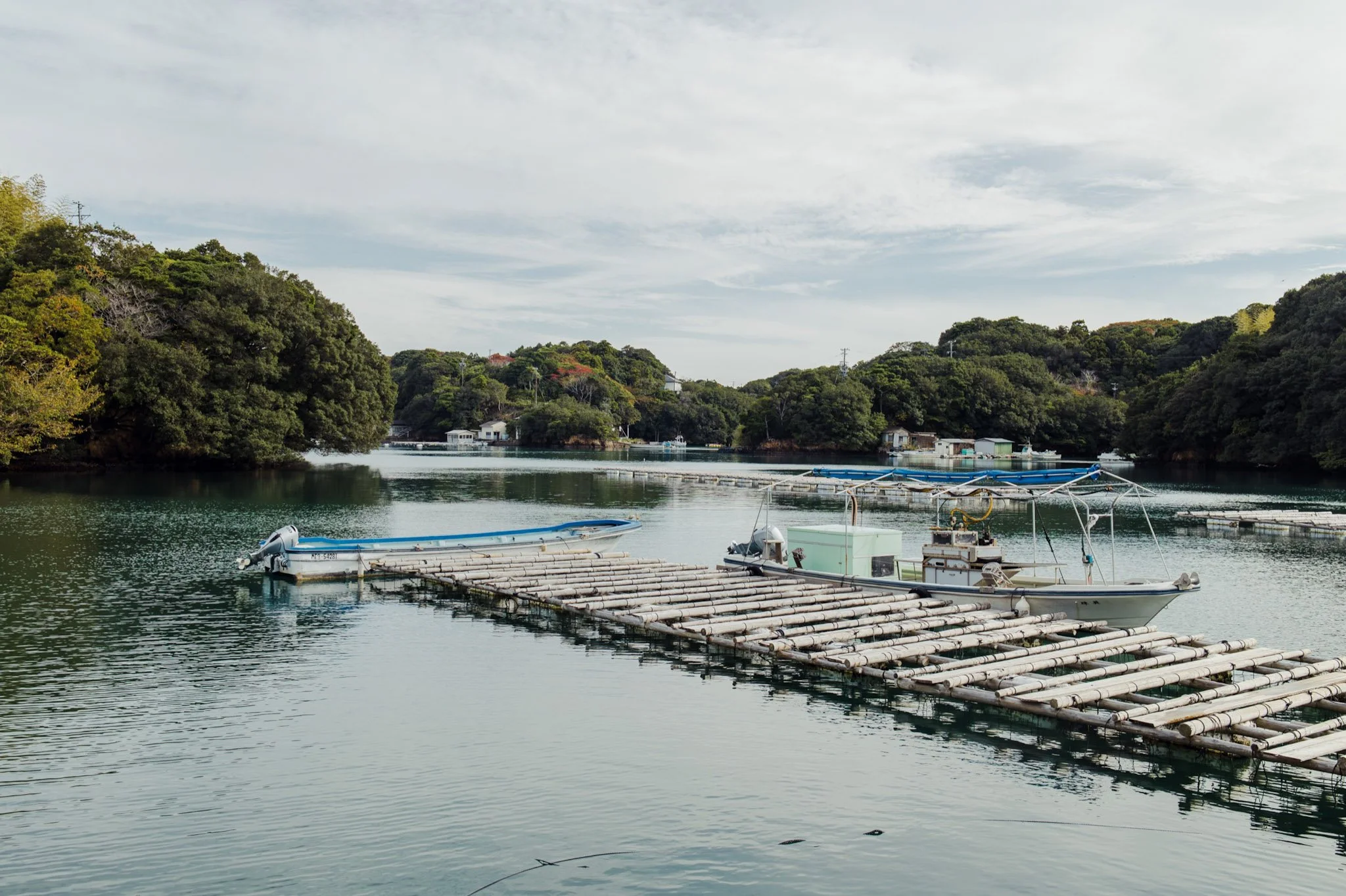
Land reclamation has expanded Japan’s territory by an estimated .5% over at least the last 850 years. When considering that two-thirds of Japan is forested (being mountainous and difficult to develop), and that Japan’s reclamation is concentrated in the bays of its large, densely-populated cities, a sizable percentage of Japan’s people–and perhaps the majority– regularly live, work, or play on land that was once open water.
The word perhaps is no accident. The first known instance of land reclamation in Japan was an island off of now-Kobe, built in 1173, which has since been subsumed into subsequent reclamation. In many Japanese cities it is often unclear, even to historians, how deep the umetatechi reaches inland from current shorelines.
Japan’s bays aren’t the only topography altered by umetatechi. Historic reclamation fill in Edo (now Tokyo), was largely produced by leveling the city’s hills–which is why Tokyo’s central wards remain a plain today. As of 2012, about 250 square kilometers, or roughly 15% of the original Tokyo Bay, has been reclaimed, constituting significant parts of Yokohama, Kawasaki, Tokyo, and Chiba.
To understand modern Japan is to understand its history of umetatechi, whose ongoing projects have shaped the nation’s landscape and economy, from ancient times to modern skylines.
The First Known Umetatechi
While softer forms of reclamation, such as filling in wetlands, have a longer history, the first documented instance of major umetatechi construction was the previously-mentioned island of Kyogashima off what is now the city of Kobe. Completed in 1173, Kyogashima was built under the direction of Taira no Kiyomori, a late Heian period court official and military leader who embarked on port development to further facilitate trade between Japan and China’s Song Dynasty.
Taira no Kiyomori's exploits were romanticized by traveling bards before being compiled into the early 14th Century’s Heike Monogatari, or The Tale of the Heike. According to this epic, construction of Kyogashima was so arduous that human sacrifice was considered, perhaps as a form of hitobashira–an ancient practice in which a person is buried alive in or near the foundation of a large construction as an appeasement to a Shinto god. But Kiyomori, the legend goes, opted instead to write a sutra on each of the island’s foundation stones, which worked to calm the elements. According to the tale, after succumbing to an intense fever, Kiyomori himself was buried on the island. Kyogashima’s final area was supposedly 37 hectares, the first of several island constructions which were eventually enveloped by Kobe’s expanding coastline.
Umetatechi and Edo Period Reclamation
In many parts of Japan’s cities, new construction projects can only be undertaken after examining old maps and records or conducting soil tests to determine whether the land is umetatechi, as reclaimed territory tends to be less compact, moister, and more prone to liquefaction during earthquakes than natural land. Nowhere is this more true than Tokyo, which has been reclaiming its bay at scale since the late 16th century.
While today’s Tokyo Station is quite removed from the coast, the land it is on used to be a narrow peninsula jutting into Edo-wan, or Edo Bay. The Hibiya Inlet separated this headland from Edo Castle (today’s Tokyo Imperial Palace), whose grounds could be directly accessed by boat. In 1592, the northern part of the Hibiya Inlet began to be filled in with soil excavated by expanding moat construction, eventually being used to house Daimyo (feudal lords) during the peaceful Edo period (1600-1867 CE).
Reclamation continued during the early Edo period, expanding into Edo Bay and contributing to what are now the special wards of Minato, Chuo, and Koto, the latter of which is almost completely umetatechi. Central Edo’s rolling hills were flattened and their soil used through a basic process that still continues to be utilized even today: a retaining wall is made of stone (now often concrete), with the encircled water pumped out and the middle filled in. The resulting Edo plain was better suited for agriculture, housing, and canal construction, whose excavated soil made fill for more reclamation. The original topography of the city was closer to what is still seen today just outside central Tokyo, like the hilly southern special ward of Ota.
While most pronounced in Edo, land reclamation was accelerating at this time throughout Japan. In Nagasaki, the fan-shaped island of Dejima was built in 1634 to facilitate Japan’s limited European trade during the Edo period’s sakoku isolationist policy, ensuring that the Portuguese and then Dutch inhabitants involved in import/export needn’t touch foot on the mainland. While Dejima was enveloped during Meiji-period Nagasaki port expansion, its outline is still visible today.
Until the late Edo period, however, umetatechi remained concentrated around central ports, as seen in art from the time period. In woodblock print master Utagawa Hiroshige’s series “The Fifty-Three Stations of the Tokaido,” the first rest area depicted along the famous Tokaido road in what is now Shinagawa, Tokyo shows Edo Bay bordering the thoroughfare. Today, the remnants of the Tokaido in Shinagawa are about a kilometer from the shore.

Modernization, Changing Materials, and Wartime Slowdown
As cargo ships grew in size, Tokyo Bay and other urban ports required deeper water. Dredging projects from the late Edo through the Taisho and Meiji periods deepened these harbors, and the sediments were used to create still more umetatechi, in contrast to the earlier practice of using soil.
Other novel materials were employed. Debris from the 1923 Great Kanto Earthquake, which devastated Greater Tokyo, were used for umetatechi. Earthquake rubble was also used to reclaim land from many of the city’s waterways as transportation continued its evolution to rail travel, with the Tokyo subway opening in 1927.
Another 1920s development was the widespread use of trash for reclaimed land, in tandem with Japan’s industrialization and production of more and more consumer and manufacturer waste.
In 1931, Haneda Airport was opened on 53 hectares of reclaimed land that the government purchased, and expanded further in 1938 with another existing umetatechi acquisition. But by then, wartime Japan’s limited resources had slowed new reclamation. Umetatechi construction wouldn’t recover till after the war.
Postwar Utopian Dreams Meet Environmental Realities
Japan’s postwar recovery began with the 1950 outbreak of the Korean War, as the country became the de facto base of U.S. operations and saw subsequent American investment into its heavy industries. Buoyed by this, the Japanese government directed much of its industrial development towards exporting, and with a lack of available real estate around harbors and historically weak powers of eminent domain, this meant the rapid creation of more artificial land. Umetatechi development, often hastily built, exploded in Japan’s Pacific coast cities of Tokyo, Osaka, Nagoya and Kobe, among other areas.
In the mid-1950s, as Japan entered what is now known as its postwar “economic miracle," it was also facing the consequences of rapid development in terms of poorly planned zoning and urban sprawl. But with the economy growing around 10% annually by 1957, a new class of idealistic designers and architects began to imagine epic public works projects to redesign Tokyo, with concepts often centering on Tokyo Bay.
Upon hearing “Neo-Tokyo," many will think of the city in Katsuhiro Otomo’s 1980s manga and animated film, Akira. But Neo-Tokyo was also the name of a 1959 design by the private think tank “Industrial Planning Conference," which reimagined the capital as a model, modern city with thoughtful zoning, ample green spaces, and super expressways. And just like Akira’s Neo-Tokyo, the design centered on Tokyo Bay with enormous umetatechi islands making up the city. This was one of several heady concepts that called for massive reclamation, forming part of the Japanese contribution to the worldwide “megastructure” design trend of the 1960s.
But during the 1970s, such dreams faded. The 1973 oil crisis ushered in the first economic contraction since the war in 1974. And though 130 square kilometers of Tokyo Bay were reclaimed from 1956 through 1975, no utopia had materialized. Instead, rapid industrialization had led to a myriad of pollution-related health issues, and Tokyo Bay, as well as the bays of other major cities, had largely been rendered a low-oxygen “dead zone” by decades of dredging and contamination. When Otomo dreamed up his Neo-Tokyo for the Akira manga, it was a dysfunctional society on the edge of collapse. In the popular imagination, Japan’s breakneck development was coming to be viewed as less a miracle and more an uncontrollable monster.
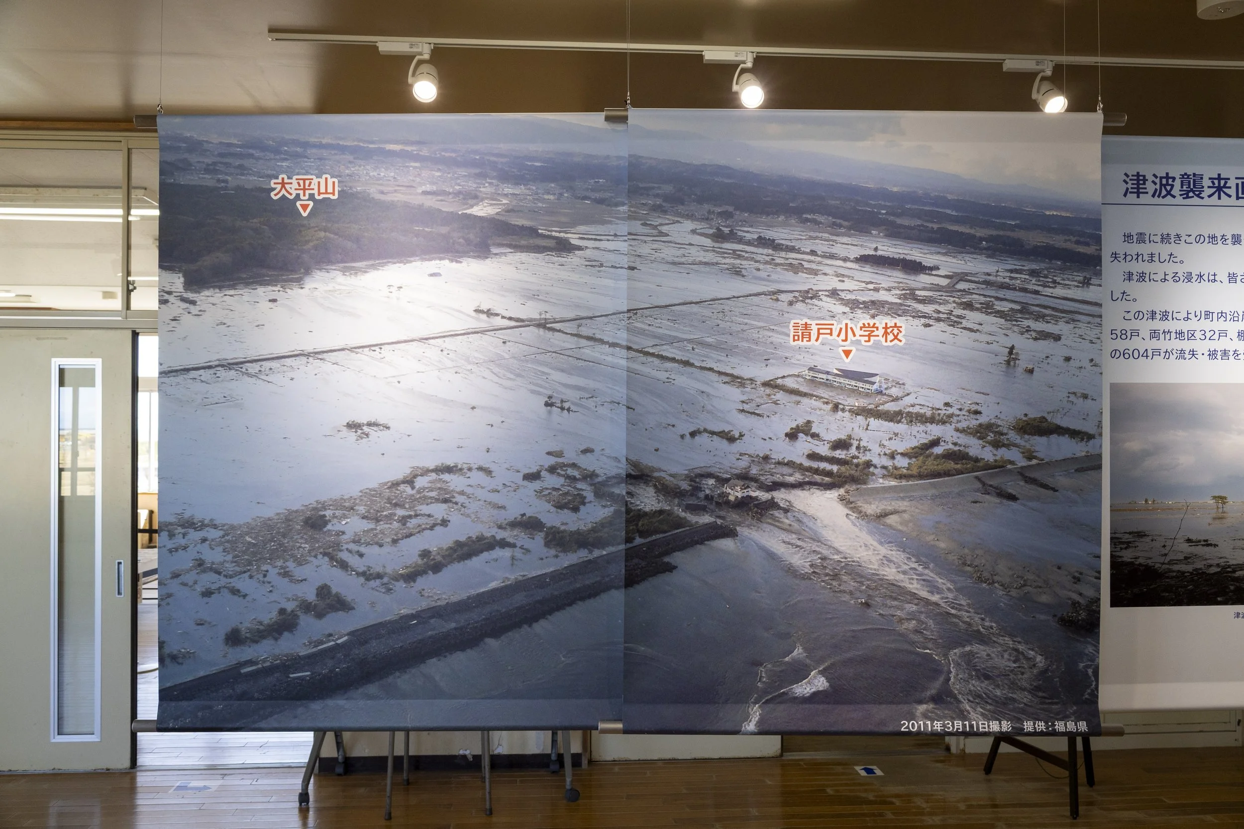
As idealism withered, so did the reclaimed land itself. Osaka’s Kansai International Airport, entirely contained on a purpose-built artificial island in southern Osaka Bay, began to sink immediately after it opened in 1994, and efforts to stabilize it continue today. And much postwar umetatechi created with dredged sediment is extremely prone to liquefaction due to its high water content and low density. The 2011 Tohoku Earthquake caused extensive damage in large parts of Chiba Prefecture’s artificial shorelines around Tokyo Bay, concentrated on areas that were predominantly made from dredgings. The trillions of yen worth of damage would have been seen as a major natural disaster in its own right, had it not been overshadowed by the tsunami and Fukushima nuclear accident.
Tsunami Debris and Modern Umetatechi
In late 2011, the first shipments of tsunami debris arrived in Tokyo Bay, destined for incineration if combustible and reclamation fill if not. With environmental reforms having been put in place since the 1970s, umetatechi construction is now a more thoughtful process, and there are even signs that Tokyo Bay’s ecosystem is recovering.
Lessons from Kansai Airport’s construction have since been applied to other artificial island hubs, like Nagoya’s Chubu International Airport (opened in 2005), Kobe Airport (2006), and ongoing expansions of Tokyo Haneda, without any of them experiencing the same subsidence issues. And as Japan has evolved to a service-based economy, its uses for artificial land are shifting. Umi no Mori Park opened this spring as a forested greenspace on 60 hectares of reclaimed land in Tokyo Bay that was formerly a landfill. New housing developments are being constructed on former brownfields. And even the huge umetatechi-based refineries and factories are being seen in a new light, with 12 cities around the country offering night boat tours of their sprawling industrial areas.
And tsunami rubble has drifted farther than Tokyo. Osaka began to accept such debris for incineration and reuse in 2013, ultimately burning 36,000 tons and using the ash to help fill in Yumeshima Island, where the World Expo opened its doors this year. The millions of guests and staff had little idea that they were walking on processed refuse from modern Japan’s worst natural disaster.
Japan’s relationship with the sea is well known in terms of cuisine, mythology, isolation, and the emergence of the country’s distinct culture. But part of that interplay is physical, with Japan creating more of itself from the water. The consequences can be great, but the process continues, and there are signs that the country is learning to build its umetatechi responsibly.
So when you are in parts of Japan’s cities near (or not so near) the ocean, look at the shorelines, search for where the hills end and the land flattens before meeting the sea, find old maps and compare them to what you see. You may become the only one who understands the ground beneath your feet.
About the Author: Thomas Shomaker is an American journalist and documentary film producer. His reporting from and articles about Japan have appeared in Nikkei Asia, the energy trade publication Japan NRG, Powderlife Magazine, and Wine Enthusiast. He has also worked with Tokyo’s Aoyama Gakuin University’s Digital Media Department producing Japanese and English video stories about their archiving efforts in collaboration with Washington D.C.’s Folger Shakespeare Library. A short documentary Thomas produced about Japan’s Obon Festival was recently part of a global Buddhism exhibit at the Übersee Museum in Bremen, Germany. He lives with his wife and their two children in Kansai’s Wakayama Prefecture.

Recommended Reads

Discover Cultural Experiences


